Avicenna J Environ Health Eng. 6(1):8-15.
doi: 10.34172/ajehe.2019.02
Original Article
Site Selection for Hazardous Waste Using Fuzzy Logic Combined With Analytic Hierarchy Process: A Case study in Nahavand, Iran
Abbas Najjari 1  , Kamran Shayesteh 1, *
Author information:
1Department of Environmental Science, Faculty of Natural Resources and Environment, Malayer University, Malayer, Hamedan, Iran
Abstract
Hazardous wastes include various types of chemicals and other wastes generated from industrial and other sources. Because of the complexity of waste management systems, the selection of the appropriate solid waste landfill site requires consideration of multiple alternative solutions and evaluation criteria. This paper investigated the utilization of the fuzzy logic in combination with Analytic Hierarchy Process (AHP) technique by applying GIS and IDRISI programming for choosing hazardous waste landfill site in Nahavand, Iran. Based on the real conditions of the study area, we considered economic, biological and topographical factors (12 criteria). The candidate sites were determined based on the criteria weights. The best location was determined via the fuzzy logic and the AHP methods. This study found that the combination of fuzzy logic and the AHP method was the best option for selecting a site for hazardous waste landfill. In the end, 6 suitable areas were selected for a hazardous waste landfill in the city. This study verified that the combination of the AHP method with fuzzy logic using GIS in our project is a powerful tool for solid waste landfill site selection.
Keywords: Hazardous waste management, Nahavand, Landfill site selection
Copyright and License Information
© 2019 The Author(s); Published by Hamadan University of Medical Sciences.
This is an open-access article distributed under the terms of the Creative Commons Attribution License (
http://creativecommons.org/licenses/by/4.0), which permits unrestricted use, distribution, and reproduction in any medium provided the original work is properly cited.
1. Introduction
Rapid industrialization gives rise to hazardous waste generation due to the increase in the consumption of products and services (1). The increasing amount of hazardous waste requires great efforts to safely dispose of them. The disposal process also includes the collection, transportation, recycling, and treatment of such waste. High costs, accompanied by risks of public health, and environmental integrity force waste managers to take suitable precautions and to explore new ways for its proper management. Locating a suitable place to dispose of the municipal solid wastes is one of the fundamental subjects related to the environmental stability of cities and, in general, the human settlements (2). Accordingly, most countries including developed and developing countries have considered suitable site selection, based on logical and scientific principles and criteria, as environmental consideration priorities (3). Regulatory compliance and cost aspects shall be considered when selecting the best hazardous waste carrier, making it a standalone decision problem for hazardous waste carrier. The safety aspect of hazardous waste transportation is a priority, therefore, the evaluation and identification of the most suitable hazardous waste carrier is a key subject for hazardous waste carrier. This decision is affected by various elements, many of which are highly vague and imprecise that need to be assessed by several experts from different backgrounds. The evaluation of various criteria for many alternatives by a group of decision makers makes this process a multi-criteria decision-making problem under group decision making. In modern societies, almost everything that is made or handled by humans sooner or later end ups as waste and to some extent turns back into the environment (4).
Meanwhile, the use of different models and methods to facilitate the decision making is inevitable because the landfill site selection based on a set of different criteria seems to be a knotty, complex, annoying, and long process (5). The landfill siting methodologies evaluate the study areas to find the zones that will minimize dangers to people and the environment (6).
Landfill siting may be a complex procedure involving social, natural and specialized parameters as well as government directions (7). Hence, the siting of landfills gets to be one of the vital processes included in waste management (8). There are wide ranges of strategies for landfill siting which utilize distinctive strategies to discover suitable areas for such establishments. In this regard, the geographic information system (GIS) is helpful because of its capacity to process huge volumes of spatial information from an assortment of sources (6-9). It plays an important role as a decision supporting tool regarding the optimum landfill sitting (10). The integration of GIS and multiple criteria analysis can be a useful method in the effective selection of a landfill location since GIS has effective control and introduction of the information and multiple criteria analysis provide steady positioning of the potential landfill zones based on an assortment of criteria (5,6).
Multi-criteria decision analysis has the capacity to evaluate multiple conflicting criteria in decision making (11). GIS has been combined with a decision–making strategy based on the analytic hierarchy process (AHP) to distinguish and rank potential landfill regions (12). In a few researches, fuzzy inference systems have moreover been proposed to assess the result of the location choice (13,14). In Thailand, fuzzy set theory combined with GIS was utilized for the screening of landfill locales (13). The combination of GIS and fuzzy multi-criteria decision making model were utilized for landfill siting in Harlingen (15). The Iranian Department of Environment supported the arrangement of landfill siting ventures in different parts of the country as a vital national arranging instrument for the administration of hazardous and non-hazardous wastes (16).
The aim of this study was to select a suitable location for hazardous waste landfills in the city of Nahavand, Iran. We used fuzzy logic combined with AHP methods for selecting the location. Subsequently, we compared it with the current landfill location.
2. Materials and Methods
2.1. Study Area
Nahavand is located in the south of Hamedan province, Iran and at the east longitude of 47° 53’ to 48° 32’ and latitude of 33° 59’ to 34° 25’ (Fig. 1). Based on the 2017 census, its population is 196 711. Nahavand lies in a semi-arid to wet region with a dry climate. Rainfall is about 376 mm per year and the average of mean daily temperature is 13.8ºC. This city generates nearly 120 tons of hazardous waste daily (people at home and also food industry), which has created several problems due to lack of appropriate site selection and relying on traditional methods of waste disposal. Therefore, considering the environmental conditions of Nahvand, determining an appropriate location for the landfill of the wastes generated based on a set of principal and logical criteria is imperative and inevitable.
2.2. Methodology
In this study, different criteria were applied to select a suitable site for landfill. The criteria were classified into three primary clusters: environmental, physical, and socio-economic. Sub-criteria, according to their characteristics and properties, were gathered as the subset of the criteria (Table 1). The main criteria and sub-criteria were specified in the schematic chart in Fig. 2. The siting of an unsafe waste landfill requires a broad assessment tool to select the ideal accessible area for waste landfill. Numerous components must be considered while evaluating a location as a suitable area for hazardous waste landfill.
Table 1.
Fuzzy Function and Membership With Control Points and Weights Utilized for Landfill Location Selection
|
Main Criteria
|
Sub-criteria
|
Control Point
|
Type of fuzzy function
|
Shape of Fuzzy Membership*
|
Weight
|
Source of Data
|
|
a
|
b
|
c
|
d
|
| Physical criteria |
Slope (%) |
5 |
- |
- |
15 |
Linear |
M.D |
0.218 |
FRWMO1 |
| Dem |
1800 |
- |
- |
2500 |
Linear |
M.D |
0.011 |
FRWMO |
| Rainfall (mm) |
400 |
- |
- |
650 |
J-shape |
M.D |
0.028 |
IRIMO2 |
| Temperature © |
5.4 |
- |
- |
12.7 |
Linear |
M.D |
0.051 |
IRIMO |
| Environmental criteria |
Land use (ranking) |
7 |
- |
- |
9 |
J-shape |
M.I |
0.047 |
FRWMO |
| Distance from surface water (m) |
300 |
- |
- |
600 |
Linear |
M.I |
0.130 |
MP3 |
| Distance from faults (km) |
1000 |
- |
- |
2000 |
J-shape |
M.I |
0.033 |
GSMEI4 |
| Vegetation density (ranking) |
2 |
- |
- |
4 |
Linear |
M.I |
0.069 |
FRWMO |
| Vegetation type (ranking) |
2 |
- |
- |
4 |
Sigmoidal |
M.I |
0.045 |
FRWMO |
| Socio-economic criteria |
Distance from villages (km) |
2 |
- |
- |
3 |
Linear |
M.I |
0.108 |
MRUD5 |
| Distance from cites (km) |
5 |
10 |
20 |
Max |
Sigmoidal |
S |
0.102 |
MRUD |
| Distance from road (km) |
0 |
2 |
5 |
10 |
J-shape |
S |
0.158 |
MRUD |
*
MD = Monotonically Decreasing, MI = Monotonically Increasing, S = Symmetric, 1. Forest, Range and Watershed Management Organization, 2. Iran Meteorological Organization, 3. Geological Survey and Mineral Exploration of Iran, 4. Ministry of Power, 5. Ministry of Road and Urban Development.
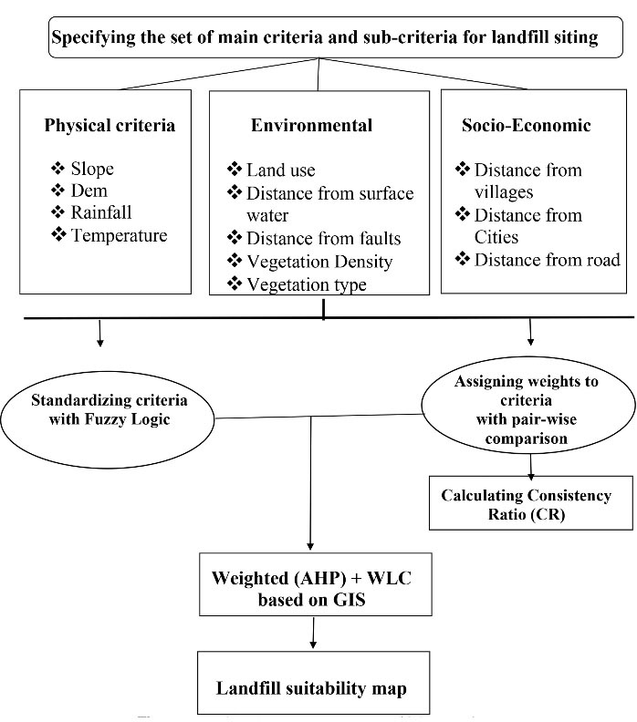
Figure 2.
The Schematic Diagram for Applied Fuzzy AHP Methodology.
.
The Schematic Diagram for Applied Fuzzy AHP Methodology.
2.2.1. Fuzzy Logic
Fuzzy logic introduced by Zadeh in 1965 permits the notion of nuance (17). Apart from being true, a proposition may be anything from almost true to hardly true (18). In comparison with the Boolean sets, a fuzzy set does not have sharply defined boundaries. The fuzzy set theory, which was a generalization of classic set theory, permitted the membership functions to operate over the range of real numbers (0,1). The most important characteristic of fuzziness is the grouping of the individuals into classes that do not have sharply defined boundaries (19). The dubious comparison may well be expressed by the fuzzy number. A triangular fuzzy number is the uncommon course of fuzzy numbers whose membership is characterized by three real numbers, expressed as (1, m, u) (20). Fuzzy sets are characterized by the fuzzy membership function. Based on a fuzzy set, A within the society of X, μ A (x) represents the consistency of the x component within the X fuzzy set which can get (21) total membership function, halfway participation or no participation (Equation 1).
Fuzzy membership functions are linear, S (sigmoid) shape and J-shaped ones (Table 2). It is additionally conceivable to characterize the fuzzy membership by the user (21).
Table 2.
AHP Pairwise Comparison
|
Intensity of Importance
|
Definition
|
Explanation
|
| 1 |
Equal importance |
Two factors have the same preference |
| 3 |
Moderate importance |
Experience and judgment slightly favor one factor over another |
| 5 |
Strong importance |
Experience and judgment strongly favor one factor over another |
| 7 |
Very strong or demonstrated importance |
A factor is preferred very strongly over another |
| 9 |
Extremely important |
The experts give one factor highest importance over another |
| 2, 4, 6, 8 |
For compromise between the above values |
Sometimes one needs to interpolate a compromise judgment numerically because there is no good word to describe it |
2.2.2. Analytical Hierarchy Process
The Analytic Hierarchy Process(AHP) is a commonly used multi-criteria technique that is incorporated into GIS-based strategies for determining suitability (22). AHP was developed by Saaty (23) to assist decision-makers to arrive at the best choice in case of numerous criteria. It is an adaptable decision-making model for multi-criteria issues and has been utilized to decide the relative significance of LSS criteria. The AHP helps decision makers to compose and assess the relative significance of selected objectives and alternative solutions. The AHP strategy may be a common decision-making strategy, which can be utilized to analyze and bolster choices with different targets. For this reason, a complex issue is partitioned into a number of less difficult issues inside the chain of command (8). The criteria (factors) are compared reciprocally in each level using the AHP method and the numerical priority is allocated according to Saaty (Table 2). In this method, weights are obtained by considering eigenvector produced from pair-wise comparisons between the criteria of the square reciprocal matrix (23).
The formula for the J-shaped function:
Where p1=point 1 and p2=point 2.
When x > point 2, then m=1. The variants of this same function can then produce each of the other j-shaped forms.
For the sigmoidal membership function, the following equation is used:
Where in case of a monotonically decreasing function:
When x < point c, m=1
In case of a monotonically increasing function:
When x > point b, m=1. (IDRISI Selva Help System).
2.3. The Stages of the Investigation
The variables used in landfill site selection are normally continuous and indicate the suitability of a zone (24). In this study, particular components were measured using the fuzzy membership function in the byte scale of 0-255 using IDRISI Selva software (Fig. 3). The presence of such a broad scale indicates the greatest possible difference while analyzing the information. Zero (0) indicates the least suitable location for a landfill while 255 shows the most ideal location for a landfill. In this investigation, a direct scaling technique was used based on the minimum and maximum values (Equation 2):
(2)
Where R= raw score, R min= Minimum score, and R max = Maximum score.
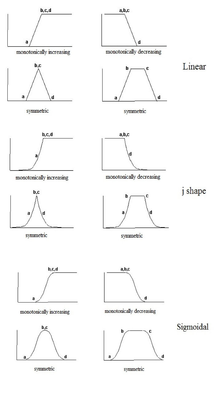
Figure 3.
Fuzzy Memberships Functions.
.
Fuzzy Memberships Functions.
After the standardization of all the variables using the fuzzy membership functions in the byte scale of 0 to 255 (Fig. 2), a weight was allotted to each layer. This weight indicated the significance of one component against the others. Each layer weight was multiplied by the standardized map (being scaled) of that layer (6). The scientific detailing of this strategy is described as follows (Equation 3):
S=Suitability, Wi=Weight of factor I, Xi=criterion score of factor i.
Combining GIS, fuzzy sets and AHP weighting method is very useful method to select a suitable area for landfills as shown in Fig. 4 (25).
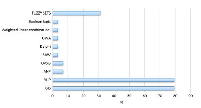
Figure 4.
Usage Percentages of Evaluation Methods in Landfill Site Selection (25).
.
Usage Percentages of Evaluation Methods in Landfill Site Selection (25).
2.4. Evaluation Criteria
The criteria affecting the selection of a landfill site are classified into three environmental, socio-economic and physical factors.
Slope: For slope, a monotonically decreasing linear fuzzy membership function was considered. In this way, according to previous studies, 5 and 15% were considered as the a and b control points for standardization.
Digital Elevation Model (DEM):A monotonically decreasing linear fuzzy membership function was utilized. Hence, based on the previous studies and literature, the elevation between 1425 (least value) and 1800 m was considered as the best range for a hazardous waste landfill.
Rainfall:A monotonically decreasing linear shape fuzzy membership function was chosen. According to other studies and experts, a precipitation of less than 400 mm was chosen as the best range for it.
Temperature:Due to the generation of leachate in landfills and other issues such as smells, temperature encompasses an uncommon range, a monotonically decreasing linear fuzzy membership function was chosen.
Land use:From the standpoint of the economy, it is better to select bare lands which can be utilized after landfill site completion or can be sold (26). Due to this circumstance, land cover classes are ranked from the worst to the best.
Vegetation density:The area with high vegetation density is not suitable for landfills and ought to be considered for other applications. Due to this circumstance, vegetation density classes are positioned from worst to best.
Distance from surface water:A monotonically increasing linear fuzzy membership function was considered. Thus, 300 and 600 (m) were chosen as the a and d control points for standardization.
Distance from faults: For this criterion, 1000 and 2000 (m) were chosen as the a and b control points with a J-shape fuzzy function.
Vegetation type:Poor and good vegetation type in addition to canopy condition in the area can have a role in selecting suitable landfill sites. Accordingly, a vegetation expert has classified the vegetation classes from the worst to the best.
Distance from villages:Due to its negative impacts, 2 and 3 (km) were chosen as the a and d control points for villages with linear fuzzy function.
Distance from cities:Selecting a landfill site close to a residential area has a negative effect since it adversely affects public health, land value, and future developments of cities (5). Due to its negative effects, sigmoidal fuzzy function and symmetric membership were chosen for it.
Distance from the main road: It is better to select a landfill site at the right distance from roads. In this manner, 0 and 2 (km) were chosen as the a and b points and 5 and 10 (km) were chosen as the c and d points with symmetric j-shape fuzzy function.
3. Results and Discussion
In this study, 12 criteria maps, including 4 physical maps, 5 environmental maps and 3 socio-economic maps, were used. As presented in Fig. 2, the primary step is standardizing all variables by fuzzy logic according to Table 1. For this reason, all the maps were standardized to 0-255 byte scale using the fuzzy module in IDRISI. This implies that areas that lack conditions for landfill were given lower values whereas those that are observed to be perfect were given higher values (closer to 255) which indicated more appropriateness (27). Fig. 5 presents the standardized maps of all utilized factors within the study. Within the following level, the AHP model was utilized to assign weights and allot relative significance to the components. The overall inconsistency was 0.05 (OI<0.1), which demonstrated an exact consistency of the judgments and reliable results.
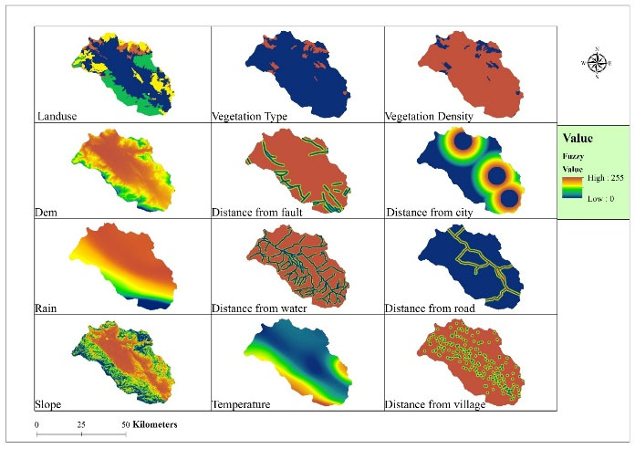
Figure 5.
Fuzzy-Based Maps.
.
Fuzzy-Based Maps.
Similar to our study, some other researches used AHP method to weight the criteria and fuzzy membership to make fuzzy maps and to select suitable sites (28-31).
Considering Table 1, the highest weights were assigned to the slope, distance from road, and distance from river which were the most important factors for this purpose. Then, the computed weights related to factors were multiplied by appropriate factor maps and all the weighted factor maps were overlaid to create suitable landfill map using WLC model (Fig. 6). As shown in the suitability map (Fig. 6), most part of the area is not suitable for landfill site. Fig. 7 shows the selected suitable map in addition to the current location map. As indicated, the current landfill location is close to region 5. The area with high suitability is located in north, southeast, and central part of the study area. Considering the population increase and current rate of waste production (120 ton per day), areas larger than 250 hectares were screened and 6 areas were selected for final evaluation (Fig. 7). Area numbered 1 and 3 had less distance from road and cannot be suitable options, area numbered 2 and 6 are very far from the waste collection centers and because of economic costs, they are not good options. Area numbered 4 had good position but considering the dominant wind direction, this site can spread bad odor of waste landfill toward Nahavand so it is not good option. Finally, area numbered 5 was determined to be a suitable area for landfill site. Table 3 shows the characteristics of the selected site (number 3) based on all 12 criteria used in the evaluation.
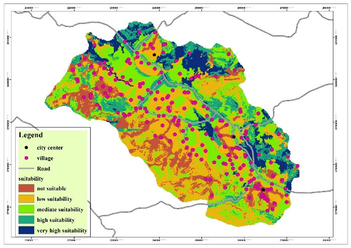
Figure 6.
Suitability Map for Landfill Site.
.
Suitability Map for Landfill Site.
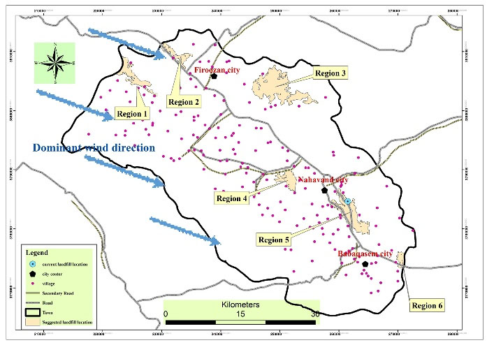
Figure 7.
Suitable Area for Landfill Sites in Nahavand.
.
Suitable Area for Landfill Sites in Nahavand.
Table 3.
Pairwise Comparison Matrix of the AHP
|
|
Slope
|
Road
|
River
|
Urban
|
Village
|
Landuse
|
Vegetation
|
Fault
|
Elevation
|
Precipitation
|
Temperature
|
Vegetation canopy
|
weight
|
| Slope |
1 |
3 |
2 |
3 |
4 |
1 |
4 |
3 |
4 |
4 |
4 |
4 |
0.196 |
| Road |
|
1 |
1/2 |
2 |
3 |
1/2 |
2 |
2 |
3 |
2 |
3 |
3 |
0.107 |
| River |
|
|
1 |
2 |
3 |
1 |
2 |
3 |
3 |
2 |
3 |
3 |
0.133 |
| Urban |
|
|
|
1 |
2 |
1/2 |
3 |
3 |
3 |
3 |
3 |
3 |
0.101 |
| Village |
|
|
|
|
1 |
1/3 |
2 |
2 |
2 |
2 |
2 |
3 |
0.068 |
| Landuse |
|
|
|
|
|
1 |
2 |
2 |
3 |
2 |
3 |
2 |
0.132 |
| Vegetation |
|
|
|
|
|
|
1 |
1/2 |
1 |
1 |
2 |
1/2 |
0.043 |
| Fault |
|
|
|
|
|
|
|
1 |
1 |
2 |
2 |
2 |
0.057 |
| Elevation |
|
|
|
|
|
|
|
|
1 |
1 |
1 |
1/2 |
0.038 |
| Precipitation |
|
|
|
|
|
|
|
|
|
1 |
1 |
2 |
0.046 |
| Temperature |
|
|
|
|
|
|
|
|
|
|
1 |
1/2 |
0.034 |
| Vegetation canopy |
|
|
|
|
|
|
|
|
|
|
|
1 |
0.034 |
We represent a case study in which spatial information technologies and fuzzy-AHP model were used in selecting landfill sites. The optimal sites were selected as candidates for waste landfill sites in Nahavand, Iran. Because in this study environmental, physical and socio-economic criteria were taken into account, the process by which the model selects landfill sites is suitable for rapidly developing cities in developing countries. We used AHP technique to assign weights to the criteria and also fuzzy membership functions for the standardization of the maps. It is clear that the assignment of factor weights is based on previous knowledge about the factor characteristics and the particularities of the study area, as well as the experience of the experts involved in the weight assignment process. Based on the final suitability map, suitable areas for landfill construction are located in the central part of the study area which has characteristics of environmental standards (Table 4). Moreover, the current landfill location shows that the site is located in an unsuitable area imposing bad effects on people since they claim that the current landfill site has endangered their health. The suggested landfill site has good environmental, physical and socio-economic advantages and can decrease waste landfill problems in the study area.
Table 4.
Characteristics of the Selected Site
|
Main Criteria
|
Sub-criteria
|
Characteristics
|
| Physical criteria |
Slope (%) |
0-5 |
| Elevation (m) |
1700-1800 |
| Rainfall (mm) |
400-450 |
| Temperature (c) |
10 |
| Environmental criteria |
Land use (ranking) |
Poor range |
| Vegetation density |
Very low |
| Distance from surface water (km) |
1-3 |
| Distance from faults (m) |
500-1500 |
| Vegetation type (ranking) |
Without vegetation |
| Socio-economic criteria |
Distance from villages (km) |
1-2 |
| Distance from Cites (km) |
5-8 |
| Distance from road (km) |
1-2 |
4. Conclusion
The increasing generation of municipal solid waste in Nahavand is one of the greatest challenges faced by governmental authorities. The development of our model is motivated by the desire to mitigate the impact of landfill sites on the environment, public health and economy. We integrated GIS and a multi-criteria evaluation technique, Fuzzy-AHP, in the assignment of site suitability for landfills. Taghizadeh et al (2013), Chitsazan et al (2013), Heydarian et al (2013), Moeinaddini et al (2010), and Ekmekciog˘lu et al (2010) in their studies have shown high capability of fuzzy-AHP model in site selection for urban wastes.
Environmental, physical and socio-economic factors were considered in the computation process, including 12 criteria categorized into three factors. Landfill sites are selected according to not only the environmental but also physical and socio-economic factors. The landfill siting process used in this study would be very useful for a fast-growing region.
The site proposed for landfill in this study has a slope of less than 5%, which can minimize the economic costs of land leveling. The precipitation in this area is about 400 mm, which has less rainfall than other parts of the city and can reduce leachate production. The air temperature is 10°C, which can reduce the activity of germs and bacteria. In terms of land use, it is located in poor and grade 3 rangelands indicating that landfills are not located in the economically valuable areas of agriculture, grade 1, and grade 2 rangelands and poor rangelands with poor vegetation are selected as suitable sites. A distance greater than one kilometer from water sources reduces the environmental risk of proximity to landfill and surface water resources. The site is at a sufficient distance from the fault to ensure that proper fault protection is observed when a possible earthquake occurs. In terms of socio-economic factors, the location of the proposed site would ensure that urban and rural health considerations are taken into account due to the appropriate distance and also the costs of transportation would not increase because of the proper distance.
The present study offers decision-makers a siting methodology and essential information for solving the waste management problem.
References
- Duan H, Huang Q, Wang Q, Zhou B, Li J. Hazardous waste generation and management in China: a review. J Hazard Mater 2008; 158(2-3):221-7. doi: 10.1016/j.jhazmat.2008.01.106 [Crossref] [ Google Scholar]
- Isalou AA, Zamani V, Shahmoradi B, Alizadeh H. Landfill site selection using integrated fuzzy logic and analytic network process (F-ANP). Environ Earth Sci 2013; 68(6):1745-55. doi: 10.1007/s12665-012-1865-y [Crossref] [ Google Scholar]
- Khan S, Faisal MN. An analytic network process model for municipal solid waste disposal options. Waste Manag 2008; 28(9):1500-8. doi: 10.1016/j.wasman.2007.06.015 [Crossref] [ Google Scholar]
- Gumus AT. Evaluation of hazardous waste transportation firms by using a two step fuzzy-AHP and TOPSIS methodology. Expert Syst Appl 2009; 36(2 Pt 2):4067-74. doi: 10.1016/j.eswa.2008.03.013 [Crossref] [ Google Scholar]
- Nas B, Cay T, Iscan F, Berktay A. Selection of MSW landfill site for Konya, Turkey using GIS and multi-criteria evaluation. Environ Monit Assess 2010; 160(1-4):491-500. doi: 10.1007/s10661-008-0713-8 [Crossref] [ Google Scholar]
- Kontos TD, Komilis DP, Halvadakis CP. Siting MSW landfills with a spatial multiple criteria analysis methodology. Waste Manag 2005; 25(8):818-32. doi: 10.1016/j.wasman.2005.04.002 [Crossref] [ Google Scholar]
- Zamorano M, Molero E, Hurtado Á, Grindlay A, Ramos Á. Evaluation of a municipal landfill site in Southern Spain with GIS-aided methodology. J Hazard Mater 2008; 160(2-3):473-81. doi: 10.1016/j.jhazmat.2008.03.023 [Crossref] [ Google Scholar]
- Nazari A, Salarirad MM, Aghajani Bazzazi A. Landfill site selection by decision-making tools based on fuzzy multi-attribute decision-making method. Environ Earth Sci 2012; 65(6):1631-42. doi: 10.1007/s12665-011-1137-2 [Crossref] [ Google Scholar]
- Javaheri H, Nasrabadi T, Jafarian MH, Rowshan GR, Khoshnam H. Site selection of municipal solid waste landfills using analytical hierarchy process method in a geographical information technology environment in Giroft. J Environ Health Sci Eng 2006; 3(3):177-84. [ Google Scholar]
- Baban SMJ, Flannagan J. Developing and implementing GIS-assisted constraints criteria for planning landfill sites in the UK. Planning Practice & Research 1998; 13(2):139-51. doi: 10.1080/02697459816157 [Crossref] [ Google Scholar]
- Geneletti D. Combining stakeholder analysis and spatial multicriteria evaluation to select and rank inert landfill sites. Waste Manag 2010; 30(2):328-37. doi: 10.1016/j.wasman.2009.09.039 [Crossref] [ Google Scholar]
- Siddiqui MZ, Everett JW, Vieux BE. Landfill siting using geographic information systems: a demonstration. J Environ Eng 1996; 122(6):515-23. doi: 10.1061/(ASCE)0733-9372(1996)122:6(515) [Crossref] [ Google Scholar]
- Charnpratheep K, Zhou Q, Garner B. Preliminary landfill site screening using fuzzy geographical information systems. Waste Manag Res 1997; 15(2):197-215. doi: 10.1177/0734242x9701500207 [Crossref] [ Google Scholar]
- Al-Jarrah O, Abu-Qdais H. Municipal solid waste landfill siting using intelligent system. Waste Manag 2006; 26(3):299-306. doi: 10.1016/j.wasman.2005.01.026 [Crossref] [ Google Scholar]
- Chang NB, Parvathinathan G, Breeden JB. Combining GIS with fuzzy multicriteria decision-making for landfill siting in a fast-growing urban region. J Environ Manage 2008; 87(1):139-53. doi: 10.1016/j.jenvman.2007.01.011 [Crossref] [ Google Scholar]
- Sharifi M, Hadidi M, Vessali E, Mosstafakhani P, Taheri K, Shahoie S. Integrating multi-criteria decision analysis for a GIS-based hazardous waste landfill sitting in Kurdistan Province, western Iran. Waste Manag 2009; 29(10):2740-58. doi: 10.1016/j.wasman.2009.04.010 [Crossref] [ Google Scholar]
- Karkazi A, Hatzichristos T, Emmanouilidi B, Mavropoulos A, Elseoud A. Landfill siting using GIS and fuzzy logic. In: Proceedings of the 8th International Waste Management and Landfill Symposium; 2001.
- Kosko B. Fuzzy Thinking: The New Science of Fuzzy Logic. New York: Hyperion; 1993.
- Hansen HS. GIS-based multi-criteria analysis of wind farm development. ScanGIS; 2005: https://vbn.aau.dk/ws/portalfiles/portal/1420302/Henning_ScanGIS_2005.pdf.
- Thalia S, Tuteja A, Dutta M. Towards Quantification of Information System Security. In: Das VV, Thankachan N, ed. Communications in Computer and Information Science, vol 250. Berlin, Heidelberg: Springer. p. 225-31. 10.1007/978-3-642-25734-6_34 .
- Gemitzi A, Tsihrintzis VA, Voudrias E, Petalas C, Stravodimos G. Combining geographic information system, multicriteria evaluation techniques and fuzzy logic in siting MSW landfills. Environ Geol 2007; 51(5):797-811. doi: 10.1007/s00254-006-0359-1 [Crossref] [ Google Scholar]
- Mosadeghi R, Warnken J, Tomlinson R, Mirfenderesk H. Comparison of Fuzzy-AHP and AHP in a spatial multi-criteria decision making model for urban land-use planning. Comput Environ Urban Syst 2015; 49:54-65. doi: 10.1016/j.compenvurbsys.2014.10.001 [Crossref] [ Google Scholar]
- Saaty TL. Decision making with the analytic hierarchy process. Int J Serv Sci 2008; 1(1):83-98. doi: 10.1504/IJSSCI.2008.017590 [Crossref] [ Google Scholar]
- Mahini AS, Gholamalifard M. Siting MSW landfills with a weighted linear combination methodology in a GIS environment. Int J Environ Sci Technol 2006; 3(4):435-45. doi: 10.1007/bf03325953 [Crossref] [ Google Scholar]
- Kahraman C, Cebi S, Onar SC, Oztaysi B. A novel trapezoidal intuitionistic fuzzy information axiom approach: An application to multicriteria landfill site selection. Eng Appl Artif Intell 2018; 67:157-72. doi: 10.1016/j.engappai.2017.09.009 [Crossref] [ Google Scholar]
- Abdoli MA. Municipal solid waste management system and its control methods. Metropolitan Recycling Organization Publication; 1993. p. 142-54.
- Taghizade diva SA, Salmanmahini A, Kheir Khah Zarkesh M. M Multi-criteria location of landfill for construction waste using a hybrid approach Fuzzy Hierarchical Analysis Case Study: Gorgan. Journal of Space Geographical Planning 2013; 3(10):122-37. [ Google Scholar]
- Chitsazan M, Dehghani F, Mirzaei SY, Rastmanesh F. Comparing AHP, WLC and AHP-FUZZY in site selecting for urban wastes (case study: Ramhormoz city). Irrigation Science and Engineering 2013; 37(1):122-37. [ Google Scholar]
- Heydarian P, Rangzan K, Maleki S, Taghizadeh A, Azizi Ghalaty S. Municipal Landfill Locating using Fuzzy-TOPSIS and Fuzzy-AHP models in GIS: A Case Study of Pakdasht City in Tehran Province. Health and Development Journal 2014; 3(1):1-13. [ Google Scholar]
- Moeinaddini M, Khorasani N, Danehkar A, Darvishsefat AA, Zienalyan M. Siting MSW landfill using weighted linear combination and analytical hierarchy process (AHP) methodology in GIS environment (case study: Karaj). Waste Manag 2010; 30(5):912-20. doi: 10.1016/j.wasman.2010.01.015 [Crossref] [ Google Scholar]
- Ekmekçioğlu M, Kaya T, Kahraman C. Fuzzy multicriteria disposal method and site selection for municipal solid waste. Waste Manag 2010; 30(8-9):1729-36. doi: 10.1016/j.wasman.2010.02.031 [Crossref] [ Google Scholar]